CT, NY, NJ Should Expect Unprecedented Flooding by Mid-Century, Scientists Predict
/
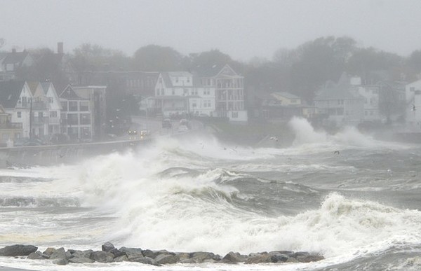
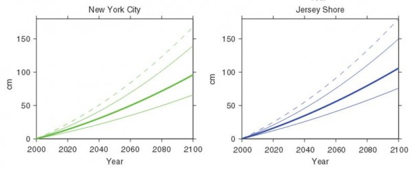
It will get worse, not better, for shoreline residents and businesses in Connecticut, New York and New Jersey within range of the Atlantic Ocean. That’s the likely scenario based on newly completed research by a team of geoscientists who are predicting that the New Jersey shore will likely experience a sea-level rise -- about 1.5 feet by 2050 and of about 3.5 feet by 2100 – that will be 11 to 15 inches higher than the average for sea-level rise globally over the century.
 That would mean that by the middle of this century, the one-in-10 year flood level at Atlantic City, for example, would exceed any flood level seen previously, including the natural disaster that was Superstorm Sandy. The scientists suggest, based on their research, that “planners should account for rising sea levels,” noting that “where the consequences of flooding are high, prudent planning requires consideration of high-end projections” outlined in their study.
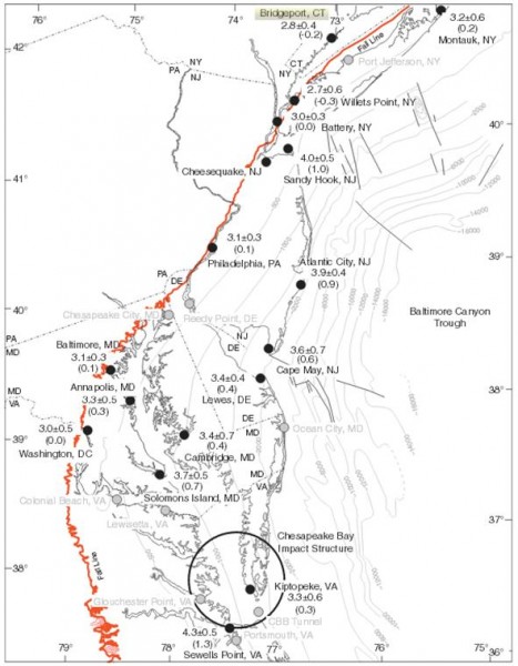
Geoscientists at Rutgers University and Tufts University base their projections in part upon an analysis of historic and modern-day records of sea-level rise in the U.S. mid-Atlantic region. Their research appears in the inaugural issue of the journal Earth's Future, published this month by the American Geophysical Union (AGU).
While much to the work centers on the New Jersey shore and The Battery in Lower Manhattan, Rutgers researcher Ken Miller told Connecticut by the Numbers that their analysis included both Montauk on Long Island and Bridgeport. Since Connecticut lies on bedrock, Miller said, it will largely behave like The Battery in New York City . “I believe that the projections for bedrock locations are applicable throughout Connecticut,” said Miller, a professor of earth and planetary sciences in Rutgers' School of Arts and Sciences.
Miller collaborated in the study with colleagues Robert Kopp, Benjamin Horton and James Browning of Rutgers and Andrew Kemp of Tufts. Kemp, an assistant professor of earth and ocean sciences at Tufts since May, joined the faculty from Yale University, where he was a Postdoctoral Associate at the Yale Climate and Energy Institute (YCEI). The new research builds upon a recent study by Kemp, Horton and others that reconstructed a 2,500-year record of sea level at the New Jersey shore. Horton is a professor of marine and coastal sciences in Rutgers' School of Environmental and Biological Sciences.
"It's clear from both the tide gauge and geological records that sea level has been rising in the mid-Atlantic region at a foot per century as a result of global average sea-level rise and the solid earth's ongoing adjustment to the end of the last ice age," Miller told Rutgers Today. "In the sands of the New Jersey coastal plain, sea level is also rising by another four inches per century because of sediment compaction -- due partly to natural forces and partly to groundwater withdrawal. But the rate of sea-level rise, globally and regionally, is increasing due to melting of ice sheets and the warming of the oceans."
The researchers suggest that “additional work is needed to integrate site-specific sea-level rise projections with storm tide statistics to guide planning decisions and investments that may have time frames of 20 years, 40 years, or longer.” They indicate that sea-le vel rise in the mid-Atlantic region also results from changes in ocean dynamics. The researchers said sea-level rise could be higher -- 2.3 feet by mid-century and 5.9 feet by the end of the century -- depending on how sensitive the Gulf Stream is to warming and how fast the ice sheets melt in response to that warming.
The study found that the eight inches of climate change-related regional sea-level rise in the 20th century exposed about 83,000 additional people in New Jersey and New York City to flooding during 2012's Superstorm Sandy. The research was supported by a grant from the National Science Foundation.
Earth’s Future, with its inaugural issue, joins AGU’s prestigious portfolio of peer-reviewed research publications, including Geophysical Research Letters and Journal of Geophysical Research – Atmospheres. Both are ranked among the top ten most-highly cited research publications on climate change over the past decade. The American Geophysical Union is dedicated to advancing the Earth and space sciences for the benefit of humanity through its scholarly publications, conferences, and outreach programs. AGU is a not-for-profit, professional, scientifi c organization representing more than 62,000 members in 144 countries.


